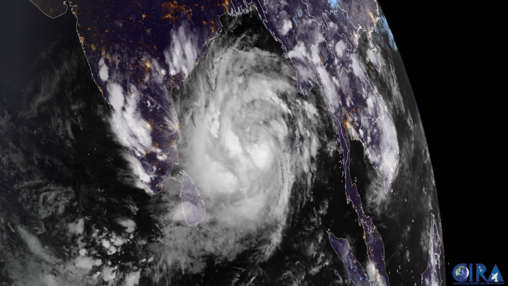
What we know: Severe Cyclone Murasu is bearing down on India’s south Andhra Pradesh coast, with landfall expected between late tonight and the early hours of Tuesday. Winds at landfall are forecast at 100–110 kmph, gusting to 120 kmph. Five districts are under a red alert for extremely heavy rain.
Where it is: At 2:30am local time on Monday, the India Meteorological Department (IMD) placed the storm’s centre over the west-central Bay of Bengal, about 260 km east-northeast of Chennai, 290 km east-southeast of Nellore and 330 km southeast of Ongole. It was moving northwest at around 20 kmph.
When it hits: The IMD expects Murasu to cross the coast between Nellore and Narsapur, close to Ongole, between 11:30pm on Monday and 4am on Tuesday. The crossing point may shift as new bulletins arrive — forecasts differ slightly on the exact stretch of coast — but the timing and strength have stayed consistent through the morning.
What is at risk: The red alert for extremely heavy rain covers Krishna, Guntur, Bapatla, Prakasam and SPSR Nellore districts for Monday, with very heavy rain also expected across Rayalaseema and parts of Telangana and south Odisha over the next two days. Chennai declared a school holiday for Monday, and schools and colleges in Andhra Pradesh’s Palnadu district were also closed. Andhra Pradesh has deployed six National Disaster Response Force teams and seven State Disaster Response Force teams to districts in the storm’s path, and Odisha is moving residents out of low-lying settlements and landslide-prone hillsides.
Why this storm feels familiar: Murasu is the second cyclone to threaten this coastline in under a week. Cyclone Arnab slammed into the same coast on 28 October with gusts up to 150 kmph, and Odisha is still dealing with the floods that followed. Back-to-back storms strain the same rescue teams, the same shelters and the same roads — and they leave less time to repair embankments and power lines between blows.
There is a reason this basin keeps producing them. The Bay of Bengal, shallow and warm at this time of year, is one of the most cyclone-prone stretches of water on Earth, and October to December is its second active season, when the retreating monsoon leaves warm seas and shifting winds in its wake. Our explainer on why the Bay of Bengal breeds such powerful storms sets out the geography behind that pattern.
Fishermen have been told to stay out of the southwest Bay of Bengal until the morning of 4 November, and those already at sea have been urged to return to port. For people in the five red-alert districts, the practical advice is the familiar kind: stay indoors during the worst of the rain, keep phones charged, and do not drive through flooded underpasses.
The IMD will issue updated bulletins through Monday as the storm closes in. The forecast track, intensity and landfall window can still change — and with a storm this close to the coast, the next bulletin matters more than this one.