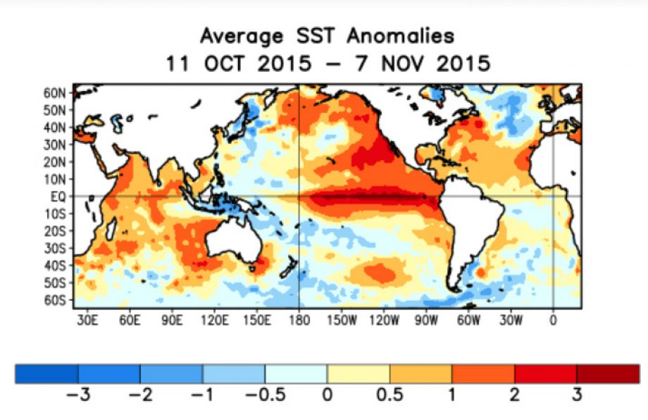
The Pacific Ocean is running a fever, and the thermometers are not supposed to read this high yet. Sea surface temperatures in the region scientists watch most closely have just set new daily records — months before the developing El Niño is expected to peak. Some researchers warn this could turn out to be the strongest such event in up to a thousand years.
Here is a clear-eyed look at what has happened, what is still uncertain, and why the rest of the world is paying attention.
What exactly broke a record?
On September 29, the daily average sea surface temperature in the Niño 3.4 region — a 2.4-million-square-mile stretch of the central and eastern equatorial Pacific that serves as El Niño’s scoreboard — reached 85.73°F (29.85°C). That is higher than any daily reading ever recorded there, according to preliminary data from the National Oceanic and Atmospheric Administration. The previous record, 85.68°F, was set in November 2015 during one of the strongest El Niño events on record.
There is an important caveat attached: NOAA says the September 29 figure is preliminary and could shift once more observations from ships, buoys and satellites are folded in. But the surrounding evidence points the same way. Buoys along a 1,000-mile stretch of the Pacific measured between 83.8°F and 87.8°F on September 30. And the 2026 temperature curve has been sitting far above the normal range all year, climbing when the seasonal cycle says it should be cooling.
Is this officially the strongest El Niño ever?
Not by NOAA’s official bookkeeping — and the reason is worth understanding. NOAA now grades El Niño strength with a new Relative Oceanic Niño Index that uses three-month averages, a method designed to better capture how the event’s heat actually reshapes weather. By that metric, the legendary 1997–98 event is still ahead of the current one.
But measure it by daily sea surface temperatures, and the 2026 event is already the most intense ever recorded. On September 21, temperatures where El Niños form ran 3.08°C above the 1991–2020 average — a record anomaly. And nearly everyone studying it expects it to keep strengthening. “It has been a remarkable event,” climate scientist Nathaniel Johnson of NOAA’s Geophysical Fluid Dynamics Laboratory told Science News. He expects it to peak within the next few months.
What is a “super” El Niño?
Any warming of more than 0.5°C above average in the Niño 3.4 region counts as an El Niño. Anything above 2°C is informally called a super El Niño. Climate analyst Zeke Hausfather, looking at output from 14 different climate models, estimated temperatures could peak around 4°C above average in November and December — deep into super territory. The 2015–16 event, by comparison, peaked at about 3.07°C above average.
“We are seeing a perfect storm of climate change and a super El Niño that is maturing so fast,” Ben Kirtman, dean of the University of Miami’s Rosenstiel School of Marine, Atmospheric and Earth Science, told USA TODAY. “Sea surface temperatures in the region are still climbing and could continue into November.”
Why are some scientists talking about a thousand years?
That framing comes from a small number of researchers speaking in interviews, not from any official agency. Climate scientist Mat Collins of the University of Exeter has said the event has reached record levels and could prove the most powerful El Niño of the past millennium. A researcher on the BBC’s More or Less program said it was “not beyond the realm of possibility” that this could be the strongest in 500 to 1,000 years.
Take the millennium framing as a measure of how unusual scientists find the current data, not as a forecast etched in stone. The honest version: by the measurements that matter, this is already behaving like something the instrumental record has never seen.
Why does this matter if I don’t live near the Pacific?
El Niño is not a regional weather event — it is a global redistribution of heat. Strong El Niños reliably fuel droughts in some places, floods in others, heat waves, severe storms, coral bleaching across entire reef systems, and disruptions to marine food chains. Federal forecasters expect the current event to intensify through the end of 2026, which puts weaker monsoons, heightened wildfire risk, and a warmer North American winter on the table.
There is also a human toll that research groups are trying to quantify. A new analysis from the University of Chicago’s Climate Impact Lab projected that the heat released by this El Niño could produce more than 450,000 additional heat-related deaths globally by next February. That is a model estimate, not a certainty — but it shows the scale of what the world’s public health systems are trying to prepare for.
What happens next?
El Niño events typically peak in the late fall or early winter, and forecasters expect this one to keep building through the end of 2026. Governments and disaster agencies are being urged to start preparing now: for drought-stressed farms, for flooded coasts, for reefs that may bleach, for energy grids under heat pressure.
The record that fell on September 29 may not survive November. That is the unsettling part — the ocean has already done the unprecedented thing, and the worst is probably still coming.