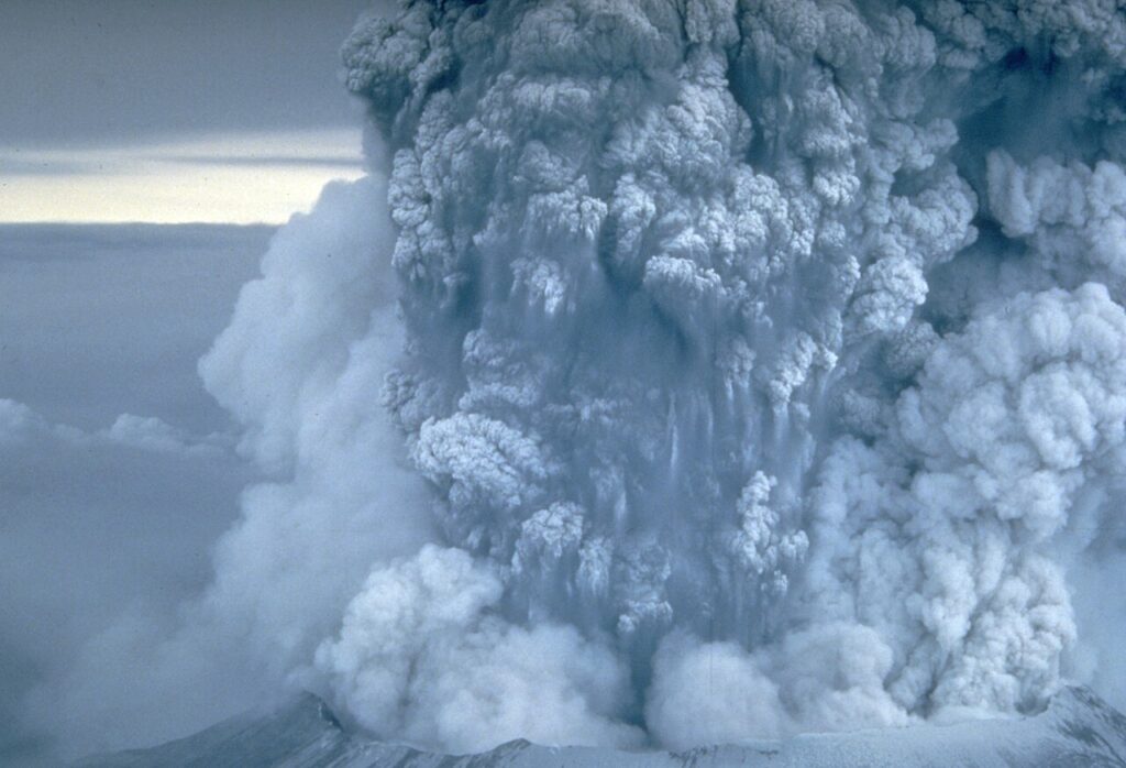
Informopedia Explains: At 8:32 on a clear Sunday morning in May 1980, a young geologist named David Johnston radioed three words from a ridge six miles north of Mount St. Helens — “Vancouver! Vancouver! This is it!” — and then the mountain came apart. A magnitude 5.1 earthquake shook the volcano’s swollen north face loose. The whole slope slid away in the largest landslide ever recorded, and the pent-up gas inside the mountain exploded sideways at hundreds of miles an hour, flattening 230 square miles of forest. Johnston was one of 57 people killed. He had spent two months watching the volcano bulge and tremble, and he still could not say which morning it would blow.
That is the honest core of volcanology. We understand the machinery of an eruption better than ever, yet the exact moment a volcano decides to erupt remains one of the hardest forecasts in science.
A volcano is a pressure cooker with a stone lid
A volcano is an opening in the Earth’s crust where molten rock, ash and gas can reach the surface. The molten rock is called magma while it is still underground; once it pours out, it becomes lava. Magma forms when rock in the mantle or lower crust melts — usually because pressure drops, because water and other volatile substances lower its melting point, or because temperatures rise.
Because magma is lighter than the solid rock around it, it rises, buoyed upward like a bubble in treacle. On the way it collects in a magma chamber, a reservoir a few kilometres below the surface that can hold cubic kilometres of melt. The chamber fills over years, decades or centuries. Pressure builds. Cracks open. And eventually some of that magma forces its way up a central conduit to the vent — the moment we call an eruption. The violence of what follows depends on two ingredients: how sticky the magma is, and how much gas it carries.
Three places on Earth where volcanoes are born
The first setting is the subduction zone, where one plate dives beneath another. As the descending plate sinks, it releases water into the mantle above, and that water lowers the melting point of the rock — producing the silica-rich, sticky magma behind the world’s most explosive volcanoes. The Pacific Ring of Fire is a chain of such zones. Peru sits above one of them: the Nazca plate slides under South America there, which is why the same region that produced a magnitude 6.8 earthquake in November 2026 also hosts some of the Andes’ most dangerous volcanoes.
The second setting is the rift, where plates pull apart and mantle rock rises to fill the gap, melting as pressure falls. Iceland sits on the Mid-Atlantic Ridge, which is why its volcanoes erupt so often. The third is the hotspot: a plume of unusually hot mantle rising through the middle of a plate, far from any boundary. Hawaii is the classic example — the Pacific plate has drifted slowly over a stationary hotspot, leaving a chain of islands that get younger toward the south-east. Yellowstone sits above another one.
According to the US Geological Survey, there are about 1,350 potentially active volcanoes on land worldwide, and around 500 of them have erupted in recorded history. The Smithsonian’s Global Volcanism Program counts roughly 50 to 70 volcanoes erupting on land in a typical year — and at least 20 are probably erupting somewhere on Earth as you read this.
What actually sets one off
Three things have to line up for an eruption, and the first is buoyancy: magma keeps rising because it is less dense than the rock around it, squeezing upward through fractures. The second is gas. Deep underground, water vapour, carbon dioxide and sulphur dioxide are dissolved in the magma the way carbon dioxide is dissolved in a sealed bottle of fizzy drink. As the magma rises and pressure falls, those gases start to bubble out of solution.
What happens next depends on the magma’s viscosity — its stickiness, set mostly by its silica content. Runny, low-silica basalt lets the bubbles rise and escape easily. The eruption is effusive: lava pours out in flows and fountains, spectacular but usually slow enough to walk away from. Thick, high-silica magma traps the bubbles. They cannot escape, so they expand with enormous force until the pressure shatters the magma into ash and rock fragments. The eruption is explosive — the shaken soda bottle with the cap ripped off.
The recipe for a violent eruption is therefore high viscosity plus lots of dissolved gas, which is why the worst blasts come from subduction zones, where wet, silica-rich magma forms.
Gentle fountains and sky-darkening blasts
Volcanologists rank eruptions on the Volcanic Explosivity Index, or VEI, proposed by Chris Newhall and Stephen Self in 1982. It runs from 0, a gentle effusive leak like Hawaii’s Kilauea, to 8, a continent-altering blast like Yellowstone’s ancient eruptions. The scale is logarithmic: each step up means roughly ten times more material thrown out. Mount St. Helens in 1980 was a VEI 5. Krakatau in 1883 was a VEI 6. A VEI 8 has not happened in recorded history.
The number captures the size of the blast, but not its reach. A modest eruption in the wrong place can paralyse a continent, while a giant one in a remote ocean may barely make the news. Three eruptions from the last fifty years show the range.
Three eruptions that rewrote the science
Mount St. Helens, 18 May 1980, is the eruption every volcanologist studies first. After two months of earthquakes and a bulge growing visibly on its north flank, a magnitude 5.1 quake at 8:32 a.m. triggered the largest landslide in recorded history. The sideways blast that followed flattened forest 27 km from the summit, and a vertical column of ash climbed 24 km into the sky, dusting eleven US states. Fifty-seven people died, including Johnston, innkeeper Harry Truman and photographer Reid Blackburn. The mountain lost 400 metres of height in a morning.
Mount Pinatubo in the Philippines, 15 June 1991, was bigger still — a VEI 6, the second-largest eruption of the twentieth century. It threw around 20 million tonnes of sulphur dioxide into the stratosphere, where the gas turned into a veil of sulphate aerosols that circled the globe and cooled the planet by about half a degree Celsius for nearly two years. More than 800 people died, and yet the eruption is remembered as a triumph of forecasting: weeks of escalating earthquakes and gas emissions gave scientists time to evacuate roughly 58,000 people, and tens of thousands of lives were saved.
Then came the small one that stopped the world. Eyjafjallajökull in Iceland, spring 2010, was only a VEI 4. But its ash was fine-grained, its plume drifted into the jet stream at about 9 km altitude, and aviation rules at the time allowed no flying through ash at all — ash melts inside jet engines and can stall them. Over six days in April, about 100,000 flights were cancelled and more than 8 million passengers were stranded across 20 countries. A volcano most Europeans could not pronounce had shut down the busiest airspace on Earth.
Listening to a mountain
Modern volcano monitoring watches four signals, because rising magma leaves fingerprints. First, earthquakes: as magma forces cracks open, it produces swarms of small quakes, often a rhythmic vibration called volcanic tremor. A swarm climbing in number and moving toward the surface is the classic first warning. Second, ground deformation: as a magma chamber fills, the ground above it swells — sometimes by centimetres, sometimes by metres — measured by GPS instruments, tiltmeters and satellite radar. Third, gas: a sudden jump in sulphur dioxide or carbon dioxide output, measured by ground spectrometers and satellites, signals fresh magma near the surface. Fourth, heat: satellites pick up warming ground and the glow of a growing lava dome, often before anything is visible from the ground.
No single signal is conclusive. The forecast only becomes confident when several line up at once, and even then the ground can change its mind: a volcano can rumble for months and then settle back to sleep, as the Nazko cone in British Columbia did in 2007.
So can we predict them?
The short answer is: we can forecast unrest, but not the hour. At a well-monitored volcano, scientists can usually say an eruption is likely within days or weeks — the Smithsonian’s Global Volcanism Program notes that reliable forecasts are rarely possible more than a few days in advance. Pinatubo proved what that warning window is worth when it is used well. But long-range prediction is a different story: recurrence intervals are notoriously unreliable, because few volcanoes have a long enough eruptive history to establish one, and because a volcano that has behaved one way for centuries can switch without notice.
The one exception proves the rule. Axial Seamount, a volcano a mile beneath the Pacific off the Oregon coast, inflates and deflates like a clockwork balloon, and wired with a fibre-optic observatory on the sea floor, scientists forecast its 2015 eruption months in advance — the only volcano ever called that far ahead. Everywhere else, the warning is measured in days. The contrast with earthquakes is instructive: why scientists still can’t predict earthquakes comes down to the same problem — the Earth gives warnings, but it does not keep appointments.
Why this matters
Volcanoes are not a curiosity for geology textbooks. Around 1,350 of them could erupt again, and tens of millions of people live in their shadow — in Naples beneath Vesuvius, in the valleys below Popocatépetl outside Mexico City, in the towns ringing Indonesia’s Merapi. When one of them wakes, the question is never whether we understand the physics. The question is whether anyone was watching, whether the warning reached the people in time, and whether they believed it. Pinatubo answered all three questions correctly. St. Helens answered the first two and still lost 57 people, because a mountain that has been quiet for 123 years is easy to underestimate.
What happens next
The gap that matters most now is coverage. Most of the world’s volcanoes have no ground instruments at all, and many sit in countries that cannot afford a monitoring network. Satellites are closing that gap: radar that measures ground swelling from orbit, sensors that sniff sulphur dioxide from space, thermal cameras that catch a warming crater — all of it watching volcanoes nobody visits. The forecasts will keep getting better in increments of days, not months, and that is worth more than it sounds. A few days was enough at Pinatubo. A few days is the difference between an evacuation and a death toll.
Johnston knew that. He spent his last two months on a ridge six miles from a mountain he knew might kill him, sending back the measurements that would let others call the next one sooner. The mountain did not warn him the morning it blew. It warns us now, in earthquakes and swelling ground and rising gas — if we are listening.