Informopedia Explains: how a buoys-and-satellites network gives coastal cities hours of warning before a tsunami — and why, in the worst cases, it can only give minutes.
On October 17, 2026, a magnitude 7.7 earthquake struck off the Indonesian island of Flores before dawn. Indonesia’s meteorology agency, BMKG, issued a tsunami warning. Hours later, it lifted it. A wave of about 1.6 meters was measured at one coastal town — real, but not the disaster the warning had feared.
A week earlier, a different 7.7 quake off Panama triggered its own round of tsunami warnings on the other side of the planet. This month alone, the world’s tsunami alert machinery has spun up, evaluated, and stood down multiple times. So how does it actually work — who decides a warning goes out, and what makes them take it back? The answer involves seafloor pressure sensors, satellites, and a system born from a disaster that arrived with no warning at all.
Why some quakes make tsunamis and others don’t
Nearly every tsunami starts with an undersea earthquake — but most undersea earthquakes produce no tsunami. Whether one forms depends less on the quake’s magnitude than on what the seafloor actually did.
The dangerous kind is a megathrust quake, where one tectonic plate slides beneath another. When the fault slips, a huge slab of seafloor lurches upward or downward in seconds, displacing the water column above it. That displaced water becomes the tsunami. Strike-slip quakes, where plates grind sideways past each other — the San Andreas fault is the famous example — barely disturb the water at all. Deep quakes also tend to be harmless: the energy dissipates before it reaches the surface.
This is why the first thing a warning center needs isn’t just how big the quake was, but where it was and how it moved — three measurements that decide everything that follows. We’ve covered the deeper puzzle of why scientists can’t predict earthquakes before; tsunamis are the rare case where, once the quake happens, prediction becomes partly possible.
The detective work: seconds to minutes
The warning chain starts with seismometers — about 600 seismic stations feed the Pacific system alone. When a quake strikes, automated software locates it and estimates its magnitude within minutes. If the numbers look threatening — roughly magnitude 7 and up, shallow, under the ocean — the first alert goes out, typically within about ten minutes.
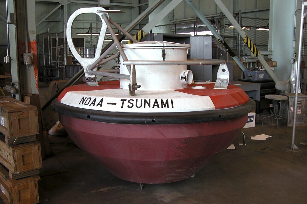
But seismic data is only a guess about what the ocean did. To find out what actually happened, the system turns to the sea itself — and that job belongs to DART: Deep-ocean Assessment and Reporting of Tsunamis. Each station is two machines in one: a pressure sensor anchored to the seafloor, connected by an acoustic link to a buoy bobbing on the surface. In the deep ocean, a tsunami is almost invisible — typically less than a meter tall, but hundreds of kilometers long, racing along at around 700 kilometers an hour. The seafloor sensor detects it not by sight but by weight: the passing wave adds water to the column overhead, and the sensor feels the pressure change.
When that pressure signature looks like a tsunami, the station switches from routine 15-minute reporting to 15-second bursts, beaming data by satellite to the warning centers in Hawaii and Alaska. This is the moment a warning shifts from model-based prediction — “a quake like this usually makes a wave” — to confirmed measurement: “a wave is actually coming, and it’s this big.”
Coastal tide gauges, roughly 500 sea-level stations in the Pacific system, provide the second confirmation layer, measuring what’s really arriving as the wave nears shore.
The alerts themselves: warning, advisory, watch
What people receive depends on where they live, but the American system — used by both US warning centers — shows the logic. The tiers, from most to least urgent — published by the US National Tsunami Warning Program:
- Tsunami Warning: inundation is expected. Flood waves are coming or imminent. Get to high ground or move inland, immediately.
- Tsunami Advisory: no major flooding expected, but dangerous currents and waves are possible in harbors and bays. Stay out of the water and away from the shore.
- Tsunami Watch: a distant quake might produce a wave; nothing confirmed yet. Be ready to act.
- Information Statement: there’s been a quake, but no tsunami threat — or the threat has passed.
For international alerts, the Pacific center sends “tsunami threat messages” to national authorities in more than a hundred locations around the Pacific rim. But here’s a detail worth knowing: those messages are guidance to governments, not orders to citizens. Each country decides what warning its own people hear. Indonesia’s BMKG, Japan’s meteorological agency, Chile’s navy — they take the international data, combine it with their own sensors, and issue the warnings their populations actually see.
When the earth itself is the alarm
All of this machinery has a built-in limit: distance. If a tsunami forms far offshore — off Chile heading for Japan, say — the system has hours to work. DART buoys confirm the wave, models refine the forecast, evacuations happen in daylight. That time is the whole reason the network exists.
But when the quake happens right off the coast — Japan in 2011, Indonesia in 2004 — the first wave can arrive in ten to twenty minutes. No satellite, no buoy, no ten-minute bulletin can outrun that. In near-field zones, the official guidance inverts: don’t wait for a warning. The earthquake itself is the warning. If the ground shakes hard for a long time — so long you can’t stand — or if the sea suddenly pulls back exposing the seabed, or you hear a loud roar from the ocean, move to high ground immediately. Japan’s system is famously fast — its first bulletin in 2011 went out about three minutes after the quake — and it still wasn’t fast enough for the nearest coasts.
Why warnings get lifted
A tsunami warning is a forecast, not a promise. It goes out when the earthquake looks capable of making a wave — because waiting for proof can cost the hours that save lives. Then the data comes in: if the DART buoys and tide gauges show no wave, or only a small one, the warning is canceled. That’s a success, not a failure. The alternative — holding a warning until the wave is visually confirmed — is no warning at all.
False alarms have a real cost, though. Evacuations disrupt ports, hospitals, and economies; cry wolf too often and people stop running. Warning centers live in the tension between those two risks on every single event. The lift notice after Flores wasn’t the system being wrong — it was the system doing what it was built to do: warn on suspicion, verify with the ocean, stand down when the water says so.
Where the system came from
The whole enterprise began with a night nobody was watching. On April 1, 1946, a tsunami generated in the Aleutian Islands slammed into Hilo, Hawaii — killing 96 people in the town in two hours, 159 across the islands. The earthquake had been recorded at 2 a.m., but the observatory that logged it was a Monday-to-Friday operation; the seismogram sat unread until staff arrived at 7:30 a.m., half an hour after the waves had hit. In direct response, the US created what became the Pacific Tsunami Warning Center, operational by 1949.
Each catastrophe added a layer. The 1960 Chilean earthquake — magnitude 9.5, the largest ever recorded — pushed the warning system to cover every Pacific nation. The 1964 Alaska quake created a second American center in Alaska. And the 2004 Indian Ocean tsunami, which killed more than 225,000 people across fourteen countries, exposed the deadliest gap of all: the Indian Ocean had no warning system whatsoever. One was built, under the United Nations’ oceanographic commission, in the disaster’s aftermath.
Why this matters
Here’s the week we’re living in: two magnitude-7.7 earthquakes, ten days apart, in two different oceans, both triggering international warning traffic — the Panama quake and Flores. The machinery spun up both times. The oceans, both times, were merciful.
It won’t always be. Coastal populations keep growing; megacities keep rising on subduction-zone shorelines — Jakarta, Lima, Manila, the Pacific Northwest. The science of warning has never been better: more buoys, faster models, phone-based alerts reaching people in seconds. But the last step — a human being deciding to run uphill — can’t be automated, and the first step — the seafloor moving — can’t be predicted.
What happens next
The frontier is speed and precision: smarter seafloor sensors, systems that estimate a quake’s tsunami potential from the seismic waves themselves, and street-by-street inundation maps. But the fundamental equation won’t change. A distant tsunami gives you hours, and the system will likely save you. A local one gives you minutes, and the system can only help if you already know the ground shaking beneath your feet is the warning.