
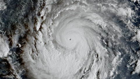
Early Friday morning, Hurricane Trudy crossed the threshold into a major hurricane — and Mexico’s Pacific coast is now squarely in its sights. The U.S. National Hurricane Center (NHC) in Miami reported maximum sustained winds of 120 miles per hour (195 km/h), making Trudy a Category 3 storm on the Saffir-Simpson scale. Forecasters expect it to keep strengthening before making its closest approach to the coastline this weekend.
As of 4 a.m. Eastern Time on Friday, October 16, Trudy’s center was sitting about 250 miles (400 kilometers) southwest of Acapulco and roughly 355 miles (570 kilometers) south-southeast of Manzanillo, Mexico’s busiest Pacific cargo port. The storm was crawling northwest at just 6 mph (9 km/h) — a slow pace that matters, because slow-moving storms linger and dump far more rain.
The NHC expects Trudy to approach the southwestern and west-central coast of Mexico on Saturday and pass near the shoreline Saturday night into Sunday, still at major-hurricane strength at its closest point. Some forecasts show winds potentially reaching 145 mph (233 km/h) — Category 4 territory — before the storm begins to weaken later in the weekend. In an earlier advisory, the center had warned that “rapid intensification is forecast to resume tonight, and Trudy is forecast to become a major hurricane Friday or Friday night.” That forecast has now come true.
A hurricane watch is in effect from north of Punta San Telmo in Michoacán state to Cabo Corrientes in Jalisco, meaning hurricane-force conditions are possible within about 48 hours. A tropical storm warning covers the coast from Punta San Telmo south to the resort town of Zihuatanejo in Guerrero. Mexico’s national weather service, the Servicio Meteorológico Nacional (SMN), has the stretch between Punta San Telmo and Playa Pérula under heightened monitoring. The U.S. Consulate General in Guadalajara issued a travel alert on Thursday for popular coastal destinations, warning of heavy rain, dangerous surf, and potential flooding.
Wind will grab the headlines, but water is the likelier killer. The NHC forecasts 4 to 8 inches (100–200 mm) of rain across Michoacán, Colima, and Jalisco through the weekend, with isolated totals up to 12 inches (300 mm). In Guerrero, 2 to 4 inches are expected, with up to 6 inches in spots. On the steep slopes of the Sierra Madre ranges just inland, that volume of rain can trigger life-threatening flash flooding and mudslides — the kind that wash out highways and cut off mountain towns. Life-threatening surf and rip currents are expected along the coast, with storm surge possible where onshore winds push seawater ashore.
Trudy is the latest chapter in an extraordinary 2026 Pacific hurricane season. Fueled by a strong El Niño climate pattern, the season has recorded the highest accumulated cyclone energy (ACE) of any Pacific season on record — 336 units, surpassing 2018 — with ten major hurricanes so far. Trudy formed on October 13 as Tropical Depression Twenty-One-E south of Guatemala, became a tropical storm the same day, and reached hurricane strength on October 15. Elsewhere in the basin, Hurricane Simon — which peaked as a Category 4 with 155 mph winds earlier this week — is weakening northwest of Trudy, while Tropical Storm Champi near Guam has put Guam and Rota under typhoon warnings.
Why this matters: the stakes reach well beyond the beach. Manzanillo is Mexico’s largest Pacific port — a major hurricane brushing it disrupts cargo flows up and down the coast. Acapulco, roughly 250 miles northeast of the storm’s current position, is still rebuilding after a string of punishing hurricane hits in recent years. And October is high season for Pacific-coast tourism: the U.S. travel alert covers resort destinations that draw millions of visitors a year, and airlines and cruise operators will be watching Trudy’s track closely.
The next 48 hours will decide how bad this gets. If Trudy’s slow northwest track holds, its center may skirt the coast rather than slam directly ashore — but in hurricane terms, “skirting” still means destructive winds, days of torrential rain, and seas forecasters describe as life-threatening. The NHC issues updated advisories every six hours, and each one will narrow the landfall question. For residents from Guerrero to Jalisco, the message is simple: finish preparations now, not on Saturday.



One Comment